|
GoogleEarth is a quite
useful tool in initial flight planning. While it offers basic weather information like IR satellite and radar imagery in the "Weather" layer, actual aviation weather data is missing.
:: Download
Open this KML file in GoogleEarth to display METARs, TAFs, and PIREPs. You might also be interested in my temporary flight restriction (TFR) display for GoogleEarth
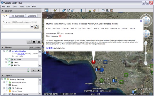
:: METARs
The symbol is according to the reported cloud cover:
| Clear below 12000 ft. This is usually an automated report, and there might be clouds above 12000 ft. This symbol is also used for the CAVOK (Ceiling and visibility OK) status |
| Sky clear |
| Few clouds |
| Scattered clouds |
| Broken clouds |
| Overcast sky |
| Sky obscured. This symbol is used when vertical visibility is reported but no cloud information |
| Missing cloud information in report |
The color of the symbol is according to the flight category:
| LIFR | Low Instrument Flight Rules: | ceiling below 500 feet AGL | and/or | visibility less than 1 mile |
| IFR | Instrument Flight Rules: | ceiling 500 to below 1,000 feet AGL | and/or | visibility 1 mile to less than 3 miles |
| MVFR | Marginal Visual Flight Rules: | ceiling 1,000 to 3,000 feet AGL | and/or | visibility 3 to 5 miles |
| VFR | Visual Flight Rules: | ceiling greater than 3,000 feet AGL | and | visibility greater than 5 miles |
:: TAFs
:: PIREPs
Note that by default PIREP display is disabled. Simply click the checkbox for it in the "Places" area of GoogleEarth.
:: Updates
The data is requested every time you change the viewing area directly from the US National Weather Service, specifically the Experimental Aviation Digital Data Service. This data is slightly less reliable than the official released weather data, and service might be unavailable at times.
Even though this data can be helpful in flight planning, do
NOT rely on the displayed data to be accurate!
Neither the original database information is fully reliable, nor
this visualization is free of programming errors.
ALWAYS get official weather information from a briefer or other
certified data sources before a flight.
To say it clearly, I'd really hate it, if anyone gets hurt
from using the little script I wrote. In Legalese this reads like
this:
The software is provided "as is", without warranty of any kind,
express or implied, including but not limited to the warranties
of merchantability, fitness for a particular purpose and
noninfringement. In no event shall the authors or copyright
holders be liable for any claim, damages or other liability,
whether in an action of contract, tort or otherwise, arising
from, out of or in connection with the software or the use or
other dealings in the software.
For further information contact: Lutz Latta (llatta at 2ld.de)
:: Back home
<Last update: 27 May 2011>
|