| TFR2KML : Visualize current Temporary Flight Restrictions (TFRs) in GoogleEarth |
|
|
||
|
new» Also check out my aviation weather display for GoogleEarth: WX2KML
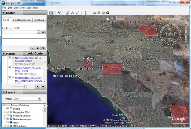
Temporary Flight Restrictions are somewhat hard to visualize when just listening to the coordinates in a standard FAA briefing, or from reading the raw NOTAM text. To make it easier to understand the affected area, the graphical displays at the FAA TFR website are very helpful, and other flight planning software can show this data as well. Since GoogleEarth is a quite useful tool in initial flight planning, I thought it might be quite helpful to see TFRs there as well. :: Download Open this KML file in GoogleEarth to display TFRs :: Updates The displayed TFR data is queried from the official Jeppesen/FAA database of TFRs on every request, eg when you open GoogleEarth, or right-click the Refresh option on the placemark. Note the time slider that will show up at the top of the display window. Some TFRs are only active at a certain time in the future, or have a pre-determined expiration date. So make sure to set the correct time range, eg start and end of a potential flight. The TFR data can be used even better in combination with the permanent airspace data from Lloyd Bailey. Even though this data can be helpful in flight planning, do
NOT rely on the displayed data to be accurate and usable for
navigational purposes! To say it clearly, I'd really hate it, if anyone gets hurt
from using the little script I wrote. In Legalese this reads like
this: For further information contact: Lutz Latta (llatta at 2ld.de) <Last update: 7 September 2008> |
||